ESR02: Seasonality of erosion and sediment transfer in mountain landscapes
Description:
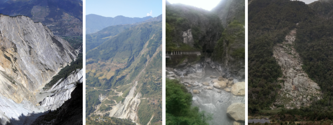
Landscapes are shaped by a phalanx of Earth surface processes, many with meteorological drivers. With the seasons, the nature, strength and location of these drivers change, so that landscape dynamics and the associated matter fluxes also have a distinct seasonality. Examples include the monsoon-dominated erosion of the Himalayas and the impact of summer typhoons on the high standing islands of the west pacific rim. In the European Alps, hillslope mass wasting may happen in a different part of the year than the flushing of sediments by flooding rivers. This geomorphic seasonality may be prone to effects of climate change in ways that determine the location and occurrence of hazards, the timing and magnitude of sediment transport, and the connectivity of process domains within mountain landscapes (the subject of ESR1). This project will aim to assemble data on the location, timing and intensity of geomorphic activity in mountain landscapes in the context of the local meteorological conditions and their seasonal change, to develop a framework for the representation of seasonality in geomorphology, and to explore its role in landscape dynamics and sediment fluxes.
In order to gather the relevant empirical data, ESR02 will collect and evaluate high-resolution seismic and independent auxiliary data from instrument networks in mountain catchments in four distinct climatic regimes: Alps, Himalayas, Taiwan, Patagonia. Seismometers are able to sense a broad range of Earth surface processes, their meteorological drivers and the geomaterial changes a catchment undergoes. Seismic data will be complemented with meteorological and hydrometric data where available.
The ESR will design, deploy and manage seismic sensor networks in exemplary active mountain landscapes. They will develop new seismic signal processing routines to robustly identify relevant Earth surface processes, to constrain their efficiency and range of material dislocation, and to quantify the space-time patterns of geomorphic activity. Training will be offered in geophysical and geomorphological techniques and approaches, large scale signal and data processing, field work, and Earth surface system understanding in a quantitative, data-driven manner.
Link to the job offer: https://www.gfz.de/karriere/stellenangebote/details/6625
Keywords: erosion, driver, connectivity, seasonality instrumentation, mountain
Host institute: GFZ Helmholtz Centre for Geosciences, Potsdam, Germany
Supervisors: Michael Dietze (Uni Göttingen, GFZ Potsdam), Jens Turowski (GFZ Potsdam), Niels Hovius (GFZ Potsdam)
Co-supervisor: Jonathan Laronne (Ben-Gurion University, Israel)
Collaborations: During the project, collaborations will be pursued to strengthen links to river sediment transport, large scale mass wasting and stochastic event understanding.